2025 Atlantic Tropical Season Outlook
Chris Johnson, Senior Meteorologist
With summer right around the corner, the Atlantic Hurricane Season is quickly approaching. The Atlantic Tropical Season officially begins on June 01st and runs through November 30th. The climatological peak of hurricane activity in the Atlantic Basin occurs in the month of September. Based on the past 30-year climatology, the Atlantic Basin generates an average of 14 named systems, 7 hurricanes, and 3 major hurricanes. For the 2025 season, we are expecting an above average season due several factors, highlighted with the El Niño Southern Oscillation (ENSO) remaining in a weak La Niña condition to Neutral condition through the summer and into the fall.
Below is a review of the main environmental conditions that promote tropical development:
Low Vertical Wind Shear (minimal change in wind speed and direction with height)
Warm Sea Surface Temperatures (primarily higher than 26.5°C or 80°F)
High Atmospheric Moisture Levels (especially from the surface to the mid-levels)
Why is 2025 going to be an above average year?
Factor #1: As mentioned above, the weak La Niña to Neutral condition of the ENSO is expected to persist through the summer and into the fall. A La Niña condition over the Equatorial Pacific is defined by cooler sea surface temperatures which, in turn, causes decreased vertical wind shear values and weaker trade winds over the Caribbean and the Gulf of Mexico. These conditions, on average, lead to warmer sea surface temperatures over the aforementioned basins.
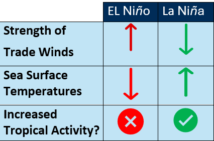
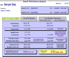
Figure 1: Impacts of ENSO on the components of tropical development.
The most recent year that resembles the current 2025 setup is 2012, where a weak La Niña state transitioned into a Neutral condition. The 2012 Atlantic Tropical Season generated 19 named storms, 10 of which became hurricanes and 2 strengthened to become major hurricanes. This season was highlighted by Superstorm Sandy that caused major damage, particularly to the New York City Metropolitan Area.
Factor #2: Sea Surface Temperatures (SSTs) are observed to be near Normal to 1°C above normal across much of the Caribbean. Across the Gulf of Mexico SSTs are running around 0.5-1.5°C above normal. This trend is expected to persist through the 2025 Atlantic Tropical Season and provide ample fuel for a slightly above average season. Warmer SSTs also promote a weaker subtropical high pressure compared to average resulting in weaker trade winds over the Tropical Atlantic Basin.
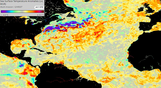
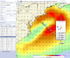
Figure 2: Sea surface temperature anomalies across the North Atlantic as of April 21st. (Courtesy of PODAAC)
Factor #3: A more active West African Monsoon is favored compared to average. This feature transports warm moist air Northward from the Equatorial Atlantic Waters into Northwestern Africa. A stronger West African Monsoon plays a significant role by developing Westward moving tropical waves during the second half of the season which have the potential to develop into Tropical Basin systems.
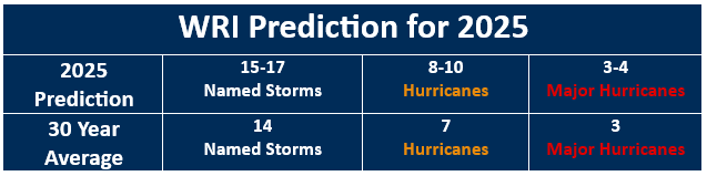
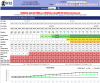
Figure 3: Official WRI Tropical Atlantic Basin predictions for the 2025 Season.
When and Where can we expect Tropical Development?
- Tropical development in June is expected to occur near North America due to the weaker trade winds and warmer SSTs compared to the open Atlantic. The primary shipping lanes that may be affected are in the Gulf of Mexico and the Yucatan Channel, as well as waters along the Southeastern coast of the United States and the Northern Caribbean.
- For July into August, as weak La Niña to Neutral ENSO conditions persist, development is expected to expand into the more open waters close to the Caribbean.
- Tropical development in August through October is expected to expand Eastward into the open waters of the Tropical North Atlantic, including the peak month of development occurring in September. A more active-than-normal Western African Monsoon will contribute to a slightly above average tropical season with repeated tropical waves coming off the Western coast of Northern Africa. These systems typically take on one of two primary routes:
Tracking Westward to threaten the Caribbean, Gulf of Mexico, and North America.
Recurving towards the Northern North Atlantic, potentially affecting more Northern latitude areas along the East and Northeastern United States and Atlantic Canadian region.
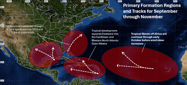
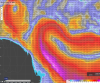
Figure 4: Potential tropical tracks through as the season progresses.
WRI and our team of meteorologists will continue to work diligently 24/7 to keep you updated of any tropical threats affecting shipping lanes across the North Atlantic. Dolphin Online’s Tropical Tracker and daily basin summaries will provide up to a week’s notice of any tropical threat or storm formation. The goal is to provide as much advance notice as possible of any tropical threat to ensure you and your crew, vessel, and clients stay safe from any potential threat.