
Volume 6 Issue 9, Dec 2013
|
Super Typhoon Haiyan
By: Amanda Delaney, Senior Meteorlogist
|

|
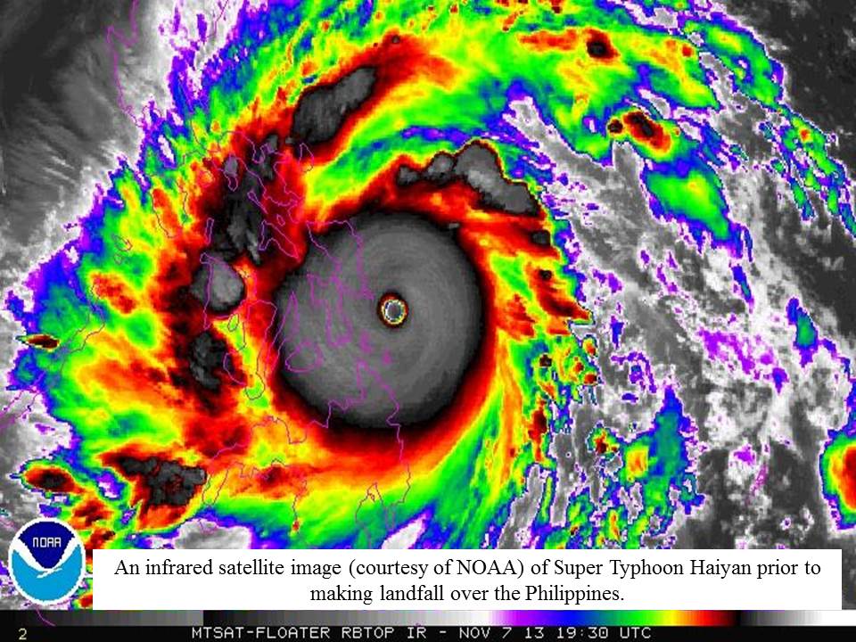
Infrared Satellite Image of Super Typhoon Haiyan
(click to enlarge)
Super Typhoon Haiyan and other Historical Tropical Cyclones:
Super Typhoon Haiyan (or known as Super Typhoon Yolanda in the Philippines) developed on November 03rd as a tropical storm approximately 750 nautical miles southeast of Guam. After a brief weakening period to a tropical depression and back to a tropical storm, the system strengthened into a minimal typhoon on November 05th with sustained winds of 65kts. The sustained winds near Typhoon Haiyan strengthened up to 130kts only 24 hours later. This upgraded Typhoon Haiyan to a super typhoon. The U.S. Joint Typhoon Warning Center (JTWC) classifies a super typhoon when a typhoon reaches sustained winds of 130kts. Super Typhoon Haiyan was approximately 300 nautical miles east-southeast of Palau at that time and continued marching to the west-northwest, passing 40 nautical miles to the north of Palau on November 06th. In that time, Super Typhoon Haiyan had sustained winds of 150kts. Infrared satellite imagery showed that the super typhoon had intense thunderstorms around the eye wall and were continuing to intensify. On November 07th, Super Typhoon Haiyan reached sustained winds of 170kts approximately 125 nautical miles southeast of Tacloban City, in the Central Philippines (see figure). By November 08th, the super typhoon passed approximately 16 nautical miles southwest of Tacloban City. Super Typhoon Haiyan continued moving west-northwest while weakening into a typhoon while passing north of Palawan by November 09th. Typhoon Haiyan tracked over the Northern South China Sea and made landfall as a tropical storm over Northern Vietnam on November 11th.
Super Typhoon Haiyan made international headlines when JTWC determined that the sustained winds of the system had reached 170kts which made the system the strongest tropical cyclone to ever hit land. The last strongest tropical cyclone to hit land was Hurricane Camille back in 1969, which made landfall over Pass Christian, Mississippi on August 17th as a category 5 hurricane. The maximum sustained winds were estimated to be 160kts and the central pressure was 909mb when Hurricane Camille made landfall.
However, there is some debate as to what the true strength of Super Typhoon Haiyan really was when it made landfall. JTWC estimated the winds using satellite derived surface wind that averages a sustained 1 minute wind. However, PAGASA (Philippine Atmospheric, Geophysical and Astronomical Services Administration), had estimated that the maximum sustained winds were approximately 160kts. They average the satellite derived surface wind data every 10 minutes. Super Typhoon Haiyan had an estimated central pressure of 895mb at landfall according to the Japan Meteorological Agency. However, the pressure can also be estimated using the Dvorak Current Intensity Chart. The Dvorak technique is a widely used system to estimate tropical cyclone intensity based solely on visible and infrared satellite images according to the U.S. Joint Typhoon Warning Center. According to the Dvorak Chart, the estimated sustained winds of 170kts would put Super Typhoon Haiyan at an 8, the highest number that can be assigned to a tropical cyclone. This would estimate the pressure to be 858mb, which would categorize Super Typhoon Haiyan to be the strongest tropical cyclone ever. Unfortunately the pressure or sustained winds will likely never be determined. The reason for this is that none of the land based weather stations that were directly impacted by the super typhoon were unable to verify these estimates prior to being destroyed by the system.
Although Super Typhoon Haiyan devastated the central Philippines, it was not the strongest super typhoon in the Northwestern Pacific. Super Typhoon Tip impacted Guam and Southern Japan in October of 1979. This system reached sustained winds of 165kts and had a central pressure of 870mb. These measurements were confirmed as hurricane reconnaissance planes made 60 trips into Super Typhoon Tip. Typically hurricane reconnaissance planes do not investigate typhoons in the Western Pacific however, with this system being close to the U.S. Airforce bases in Guam and Japan, investigating was permitted at the time. Not only was Super Typhoon Tip the strongest tropical cyclone ever, the system is also the largest tropical cyclone ever. Super Typhoon Tip measured approximately 1380 miles across compared to Super Typhoon Haiyan, which measured approximately 1050 miles across. To put this in prospective, Super Typhoon Tip would have covered approximately half of the continental United States.
Is it unusual to have a Super Typhoon in the Northwestern Pacific?
The Northwestern Pacific Ocean is the most active basin for tropical cyclones. Since the 1960’s, the Northwestern Pacific Ocean averages approximately 25-26 tropical cyclones (that reach tropical storm status or stronger) per year and approximately 16 typhoons per year. Since 1996, there has been an average of 5 super typhoons that have formed in the Northwestern Pacific Ocean. The Philippines are impacted by the most tropical cyclones in the world, averaging 6-7 tropical cyclone strikes annually.
This year was more active than normal. So far, 29 named tropical cyclones have developed and 13 of those were typhoons. 7 of those typhoons reached super typhoon status. Most of the time, when a tropical cyclone reaches super typhoon status, it occurs well out in open waters. Aside from Super Typhoon Haiyan, another tropical cyclone made super typhoon status 6 hours before landfall in Luzon this year and that was Super Typhoon Utor. This system weakened to sustained winds of 120kts when it made landfall over the Northern Philippines in August.
Forecasting a Super Typhoon and Preperation
Our technology has come a long way over the years to provide ample warning to the public and ships at sea. Super Typhoon Haiyan was a well forecasted system. Various models were consistent that this tropical cyclone was going to develop and strengthen rapidly while moving towards the Philippines. This allowed time for most ships at sea to move safely away from the tropical cyclone and allowed people to evacuate to higher ground in the Philippines. The greatest challenge is forecasting the strength of these systems. Super Typhoon Haiyan strengthened from a minimal typhoon of 65kts to a super typhoon of 130kts in 24 hours, and this was still 24 hours prior to making landfall over the Philippines. Even with all of the preparation taken to move to strong structured buildings and higher ground, every building in the areas in Samar and Leyte (in locations that were directly hit by the super typhoon) were either damaged or destroyed and trees were leveled. The storm surge in these areas reached as high as 5-6 meters!
Although the headlines of the devastation in the Philippines will fade over the coming weeks, it will take years to recover from the damage by Super Typhoon Haiyan. Food, water and essential supplies are still required to help approximately 7 million people affected by the tropical cyclone according to the Philippine Government. Below are some links to a few of many groups assisting with the relief effort:
International Committee of the Red Cross: http://www.icrc.org/eng/
The United Nations World Food Programme: http://wfpusa.org/
UNICEF: https://secure.unicefusa.org/s
Doctors Without Borders: http://www.doctorswithoutborders.org/
In this issue:
WRI Services:
Contact us for a Forecast!
wri@wriwx.com
+1-518-798-1110
Visit the new SeaWeather and request a trial!
Click Here
Racing Forecasts for Racers
Click Here
WRI Fishing Charts for Anglers!
Click Here
Marina Forecasts
Click Here
Heavy Weather Alerts
Click Here
WRI Meteograms
Click Here
WRI Reward Program
 WRI is very appreciative when our clients recommend our services to other captains in the industry.
Therefore, as a token of our gratitude, we have established a
If 5 captains mention your name as a referral to our service, we will mail you a $100 USD Visa Gift Card to be used with any purchase.
 Need a Forecast?
Contact our professional meteorologists
Need a Forecast?
Contact our professional meteorologists
24 hours a day, 365 days a year at
(518) 798-1110
or wri@wriwx.com


Unsubscribe
WRI Services:
Contact us for a Forecast!
wri@wriwx.com
+1-518-798-1110
Visit the new SeaWeather and request a trial!
Click Here
Racing Forecasts for Racers
Click Here
WRI Fishing Charts for Anglers!
Click Here
Marina Forecasts
Click Here
Heavy Weather Alerts
Click Here
WRI Meteograms
Click Here
WRI Reward Program
WRI is very appreciative when our clients recommend our services to other captains in the industry.
Therefore, as a token of our gratitude, we have established a
WRI Mariners Acquire Rewards
program to benefit our captains.
If 5 captains mention your name as a referral to our service, we will mail you a $100 USD Visa Gift Card to be used with any purchase.
Need a Forecast?
Contact our professional meteorologists24 hours a day, 365 days a year at
(518) 798-1110
or wri@wriwx.com
Unsubscribe